GROUNDWATER AND AQUIFERS
Groundwater Research
Fifteen years of interdisciplinary hydrogeological work on island groundwater resources
Guam, like the other islands in the Western Pacific with significant limestone terrain, relies primarily on groundwater to support its growing population and developing economy. The Northern Guam Lens Aquifer, which is comprised of the limestone bedrock forming the plateau that occupies the northern half of the 214-square-mile island, supplies about 80% of the potable water for Guam. WERI´s groundwater research program, launched by Dr. John Jenson in 1994, has focused on developing a more accurate conceptual model for the unique aquifers on islands and coastal provinces comprised of geologically young limestone islands, as well as gaining a better understanding of the dynamic processes of recharge, vadose and phreatic transport, and coastal discharge in these types of aquifers
Groundwater Modeling: Applications to the Northern Guam Lens Aquifer
Collaborative work to develop a numerical model for the Northern Guam Lens Aquifer included some of the pioneering work on two-phase numerical models of “saltwater intrusion” in the early 1980s by Dr. Dinshaw Contractor of the University of Arizona´s Department of Civil Engineering and Engineering Mechanics (Contractor, 1981, 1983; Contractor et al., 1981; Contractor and Srivastava, 1990). Work begun by Dr. Contractor, working with WERI through the 1980s and into the early 1990s, was expanded and intensified with arrival of Dr. John Jenson at WERI in 1993. Dr. Jenson and Dr. Contractor collaborated through 1998 to extend the development and application of Dr. Contractor´s finite-element code, SWIG2D, to obtain better estimates of aquifer recharge (Jocson et al., 2002) and vadose transport dynamics (Contractor and Jenson, 2000) in the Northern Guam Lens Aquifer. More recent work at WERI has included the application of the US Geological Survey´s SUTRA code to a unique data set obtained in 2004 by an intensive instrumentation of selected observations wells, sponsored by the Guam Environmental Protection Agency (Olsen and Hormillosa, 2008; Wuerch et al., 2007).
Back to top ^
Field Studies: The Carbonate Island Karst Model
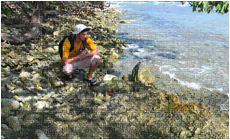
South end of Haputo Bay, one of the striking enscalloped embayments in the limestone coast of northwestern Guam. Groundwater flows from seeps and springs in the beach here, and from flowing fractures and caves in cliff faces to the north and south of the bay.
The modeling work of the mid-1990s made it apparent that a more accurate and detailed conceptual model was needed for the Northern Guam Lens Aquifer and similar aquifers in geologically young limestones elsewhere. For such aquifers, neither the classical Darcian model for porous media nor the classical karst model of conduit and fracture flow is adequate: porous flow, fracture flow, and conduit flow combine in complex ways to play important roles in carbonate island aquifers. Impressed that the most relevant extant work was that by Mylroie and Carew (1995) on the karst of the low-lying, tectonically stable islands of the Caribbean and Western Atlantic, Dr. Jenson approached Dr. John Mylroie, of Mississippi State University, Department of Geosciences, in 1997 about undertaking a collaborative study of the more complicated uplifted and tectonically active islands of the Mariana Islands. Beginning on Guam in 1998 (Mylroie et al., 2001), Dr. Jenson, Dr. Mylroie, their associates, and students conducted intensive investigations to document the coastal and interior karst features of Mariana Islands, conducting successive studies of Saipan (Wexel, 2007), Tinian and Aguijan (Stafford et al., 2004a; Stafford et al., 2003; Stafford et al., 2004b; Stafford et al., 2005), and Rota (Keel et al., 2004, 2005a; Keel et al., 2005b). From their combined work of 1998-2005, they have developed the Carbonate Island Karst Model or CIKM (Jenson et al., 2006; Mylroie and Jenson, 2000). While the CIKM is a conceptual model of island karst, rather than of island karst aquifers, per se, it provides the essential geological context for the development of an accurate, detailed conceptual model for these complicated aquifers.
Back to top ^
Saltwater Intrusion
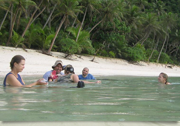
WERI researchers Michelle Hoffman and Dave Moran place activated charcoal “dye bugs” in the discharge stream from Ayuyu (Coconut Crab) on the northwest coast of Guam. (See photo below.)
Eighty percent of Guam´s drinking water is supplied by over 100 wells that produce an average of 50 million gallons per day for the islands 150,000 residents and over 1,000,000 tourists who visit the island each year. During the 1980 through the mid-1990s, the water production system was greatly expanded to meet the needs of the rapidly growing economy. In response to concerns over the incidence, severity, trends, and causes of elevated chloride in various wells, WERI undertook a comprehensive historical study, examining not only the chloride record for each well, but the hydrogeological setting, and the well construction and operating history. The study (McDonald and Jenson, 2003) provides a detailed report on the water quality (in terms of chloride) and the observed trends in each well, along recommendations for management of each well. For wells exhibiting high chloride concentrations, the report contains an assessment of the causes and recommendations for remediation or closure.
Back to top ^
Dye Trace Studies
Field studies of the karst were augmented with a dye trace study, conducted with support from Guam Environmental Protection Agency, from 2000 to 2002 (Moran and Jenson, 2004). This study, along with previous studies conducted by consultants for military remediation projects in the 1990s (AAFBER, 1995; Barner, 1995, 1997), provided compelling evidence for conduit and fracture flow, as well as an important component of porous flow in the aquifer. Uncertainties over the interpretation of results motivated an intensive study of the background fluorescence in the coastal waters of Guam, from 2005 through 2007 (Hoffman et al., 2008; Hoffman et al., 2007). Results of this study provide a reliable assessment of the likely incidence and sources of background fluorescence in tropical waters of limestone coasts, against which to evaluate dye trace results on Guam and similar islands and coastal environments.
Current and anticipated work
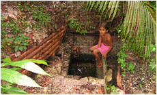
WERI researchers John Jocson, Arne Olsen, Dave Moran (left to right) at Ayuyu (Coconut Crab) Cave on the northwest coast of Guam. A spectacular flow of fresh water can be observed from the moth of the cave when the tide is low and the surf is calm.
Effort is underway to re-kindle and extend the study of the coastal discharge features on Guam. A proposal for a collaborative study is being prepared to sponsor an interdisciplinary study that would quantify the mass flux and solute concentrations of submarine groundwater discharge (SGD) at selected locations along the northwest coast of Guam, to include the concentration and origins selected nutrients, and ultimately, their effects on reef health.
Back to top ^
References
- AAFBER, 1995, Final Report: Groundwater dye trace program and well cluster proposal for the landfill area, Andersen Air Force Base, Guam, Archived at University of Guam Library, Mangilao, Guam.
- Barner, W. L., 1995, Ground water flow in a young karst terrane developed along a coastal setting, northern Guam, Mariana Islands: Int. Res. Appl. Cen. Karst Water Res., Karst Waters Institute, Seminar field course, p. 12.
- Barner, W. L., 1997, Time of travel in the fresh water lens of northern Guam: Proceedings of the Eighth Symposium on the Geology of the Bahamas and Other Carbonate Regions, p. 1-12.
- Contractor, D. N., 1981, A two-dimensional, finite-element model of salt water intrusion in groundwater systems, WERI Technical Report No. 26, Mangilao, Water & Energy Research Institute, University of Guam.
- Contractor, D. N., 1983, Numerical modeling of saltwater intrusion in the Northern Guam Lens: Water Resources Bulletin, v. 19, p. 745-751.
- Contractor, D. N., J. F. Ayers, and S. J. Winter, 1981, Numerical modeling of salt-water intrusion in the Northern Guam Lens, WERI Technical Report No. 27, Mangilao, Water & Energy Research Institute, University of Guam.
- Contractor, D. N., and J. W. Jenson, 2000, Simulated Effect of Vadose Infiltration on Water Levels in the Northern Guam Lens Aquifer: Journal of Hydrology, v. 229, p. 232-254.
- Contractor, D. N., and R. Srivastava, 1990, Simulation of saltwater intrusion in the Northern Guam Lens using a microcomputer: Journal of Hydrology, v. 118, p. 87-106.
- Hoffman, S. M., J. W. Jenson, G. R. W. Denton, D. C. Moran, and H. L. Vacher, 2008, Variability of Background Fluorescence in Tropical Karst Aquifers, 14th symposium on the geology of the Bahamas and other carbonate regions, Gerace Research Center, San Salvador Island, Bahamas.
- Hoffman, S. M., J. W. Jenson, D. C. Moran, G. R. W. Denton, H. R. Wood, and H. L. Vacher, 2007, Background fluorescence in Guam's coastal waters, WERI Technical Report No. 121, Mangilao, Water & Environmental Research Institute of the Western Pacific, University of Guam.
- Jenson, J. W., T. M. Keel, J. R. Mylroie, J. E. Mylroie, K. W. Stafford, D. Taborosi, and C. Wexel, 2006, Karst of the Mariana Islands: The interaction of tectonics, glacio-eustasy, fresh-water/salt-water mixing in island carbonates: Geological Society of America Special Paper, v. 404, p. 129-138.
- Jocson, J. M. U., J. W. Jenson, and D. N. Contractor, 2002, Recharge and Aquifer Response: Northern Guam Lens Aquifer, Guam, Mariana Islands: Journal of Hydrology, v. 260, p. 231-254.
- Keel, T. M., J. E. Mylroie, and J. W. Jenson, 2004, Preliminary report on the caves and karst of Rota (Luta), CNMI, WERI Technical Report No. 105, Mangilao, Water & Environmental Research Institute of the Western Pacific, University of Guam.
- Keel, T. M., J. E. Mylroie, and J. W. Jenson, 2005a, The caves and karst of Rota Island, Commonwealth of the Northern Mariana Islands, WERI Technical Report No. 107, Mangilao, Water & Environmental Research Institute of the Western Pacific, University of Guam.
- Keel, T. M., J. E. Mylroie, J. R. Mylroie, and J. W. Jenson, 2005b, The cave and karst of Rota Island, Commonwealth of the Northern Mariana Islands: Journal of Cave and Karst Science, v. 67, p. 187.
- McDonald, M. Q., and J. W. Jenson, 2003, Chloride history and trends of water in production wells in the Northern Guam Lens Aquifer, WERI Technical Report No. 98, Mangilao, Water & Environmental Research Institute of the Western Pacific, University of Guam.
- Moran, D. C., and J. W. Jenson, 2004, Dry trace of groundwater from Guam International Airport and Harmon Sink to Agana Bay and Tumon Bay, WERI Technical Report No. 97, Mangilao, Water & Environmental Research Institute of the Western Pacific, University of Guam.
- Mylroie, J. E., and J. L. Carew, 1995, Karst development on carbonate islands, in D. A. Budd, P. M. Harris, and A. Saller, eds., Unconformities and Porosity in Carbonate Strata, v. Memior 63, American Association of Petroleum Geologists, p. 55-76.
- Mylroie, J. E., and J. W. Jenson, 2000, The Carbonate Island Karst Model applied to Guam: Theoretical and Applied Karstology, v. 13-14, p. 51-56.
- Mylroie, J. E., J. W. Jenson, D. Taborosi, J. M. U. Jocson, D. T. Vann, and C. Wexel, 2001, Karst features on Guam in terms of a general model of carbonate island karst: Journal of Cave and Karst Studies, v. 63, p. 9-22.
- Olsen, A. E., and T. Hormillosa, 2008, Northern Guam Vadose Zone: 30 Years of WERI Research, Gerace Research Centre 14th Geology Conference, San Salvador, Bahamas.
- Stafford, K., J. Mylroie, D. Taboroši, and J. W. Jenson, 2004a, Eogenetic karst development on a small, tectonically active, carbonate island: Aguijan, Mariana Islands: Cave and Karst Science: Transactions of the British Cave Research Association, v. 31, p. 101-108.
- Stafford, K. W., T. M. Keel, J. E. Mylroie, J. W. Jenson, and J. R. Mylroie, 2003, Eogenetic karst development in the Mariana Islands: Aguijan, Rota, and Tinian: Journal of cave and Karst Studies, v. 65, p. 188.
- Stafford, K. W., J. E. Mylroie, and J. W. Jenson, 2004b, Karst geology of Aguijan and Tinian, CNMI cave inventory and structural analysis of development, WERI Technical Report No. 106, Mangilao, Water & Environmental Research Institute of the Western Pacific, University of Guam.
- Stafford, K. W., J. E. Mylroie, D. Taboroši, J. W. Jenson, and J. R. Mylroie, 2005, Karst development on Tinian, Commonwealth of the Northern Mariana Islands: Controls on dissolution in relation to the carbonate island karst model: Journal of Cave and Karst Studies, v. 67, p. 14-27.
- Wexel, C., 2007, Karst features of Saipan in terms a general carbonate island karst model: Masters thesis, University of Guam.
- Wuerch, H. V., B. C. Cruz, and A. E. Olsen, 2007, Analysis of the Dynamic Responses of the Northern Guam Lens Aquifer to Sea Level Change and Recharge, WERI Technical Report No. 115, Mangilao, Water & Environmental Research Institute of the Western Pacific, University of Guam.
Back to top ^